


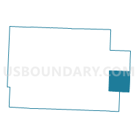
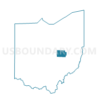
PRECINCT OXFORD, Coshocton County, Ohio
About
Outline

Summary
| Unique Area Identifier | 643807 |
| Name | PRECINCT OXFORD |
| County | Coshocton County |
| State | Ohio |
| Area (square miles) | 25.81 |
| Land Area (square miles) | 25.25 |
| Water Area (square miles) | 0.55 |
| % of Land Area | 97.86 |
| % of Water Area | 2.14 |
| Latitude of the Internal Point | 40.25515640 |
| Longtitude of the Internal Point | -81.65511000 |
Maps

Graphs
Select a template below for downloading or customizing gragh for PRECINCT OXFORD, Coshocton County, Ohio


Neighbors
Neighoring Voting District (by Name) Neighboring Voting District on the Map
- PRECINCT ADAMS, Coshocton County, OH
- PRECINCT LAFAYETTE EAST, Coshocton County, OH
- PRECINCT LINTON, Coshocton County, OH
- PRECINCT MONROE/WHEELING, Guernsey County, OH
- PRECINCT NEWCOMERSTOWN #1, Tuscarawas County, OH
- PRECINCT NEWCOMERSTOWN #3, Tuscarawas County, OH
- PRECINCT OXFORD TOWNSHIP, Tuscarawas County, OH
- PRECINCT WHITE EYES, Coshocton County, OH
Top 10 Neighboring County Subdivision (by Population) Neighboring County Subdivision on the Map
- Oxford township, Tuscarawas County, OH (4,964)
- Lafayette township, Coshocton County, OH (4,081)
- Oxford township, Coshocton County, OH (1,527)
- White Eyes township, Coshocton County, OH (1,194)
- Adams township, Coshocton County, OH (790)
- Wheeling township, Guernsey County, OH (686)
- Linton township, Coshocton County, OH (646)
Top 10 Neighboring Place (by Population) Neighboring Place on the Map
Top 10 Neighboring Unified School District (by Population) Neighboring Unified School District on the Map
- Ridgewood Local School District, OH (8,649)
- Newcomerstown Exempted Village School District, OH (6,421)
Top 10 Neighboring State Legislative District Lower Chamber (by Population) Neighboring State Legislative District Lower Chamber on the Map
- State House District 96, OH (124,049)
- State House District 94, OH (117,946)
- State House District 93, OH (116,725)
Top 10 Neighboring State Legislative District Upper Chamber (by Population) Neighboring State Legislative District Upper Chamber on the Map
Top 10 Neighboring 111th Congressional District (by Population) Neighboring 111th Congressional District on the Map
Top 10 Neighboring Census Tract (by Population) Neighboring Census Tract on the Map
- Census Tract 217, Tuscarawas County, OH (5,474)
- Census Tract 9618, Coshocton County, OH (4,990)
- Census Tract 9772, Guernsey County, OH (4,821)
- Census Tract 9609, Coshocton County, OH (4,652)
- Census Tract 9612, Coshocton County, OH (3,218)